
Mamore Hill [Cnoc an Mhaim Mhoir]
Good walks are even better shared.
Overview
Mamore Hill [Cnoc an Mhaim Mhoir]
Overview
Mamore Hill, known in Gaelic as Cnoc an Mhaim Mhoir, stands proudly at an elevation of 788 meters. A Marilyn classification means it boasts a prominence of over 150 meters, making it a significant feature in the Scottish Highlands.
Geology
The mountain's geology is fascinating, primarily composed of schist. The area is a testimony to the Highland's geological history, showcasing classic glacial features that tell tales of the last Ice Age. As you ascend, take a moment to ponder the geological stories that lie beneath your feet.
Routes
One of the most popular routes to the summit is the Mamore Hill Circuit. Starting from a roadside layby, it encompasses about 10.5 km and can be tackled in around 4 hours, depending on how many times you stop for breathtaking selfies. The terrain here is moderate but rewarding!
Summit Features
At the summit, you'll find a prominent trig point standing tall alongside a stone cairn. These landmarks not only provide direction but also a perfect spot for those obligatory summit photos.
Terrain
Expect a delightful mix of rocky paths and heather-covered slopes. Watch out for the boggy patches that are as famous as they are slippery. Pack your best boots and don't let them go astray!
Views
From the summit, the panoramic views are nothing short of spectacular. The Lochaber region lies sprawled out beneath you, with a stunning sight of Loch Leven and the Ben Nevis massif waiting in the wings for you to admire. The best seasons for beautiful views are late spring through early autumn, when the scenery is in full bloom and visibility is at its best.
Hazards
As with any Highland adventure, be mindful of rapidly changing weather conditions. Ensure you're equipped for all eventualities, and be cautious on the rugged terrain.
Nearby Summits
If you’re feeling adventurous, consider bagging nearby peaks like Sgor Eilde Mor at 970 meters and Cnoc na h-Uamha at 678 meters. Each offers its unique vistas and challenges.
Access
Nearest Parking
You can park at a small layby on the C324436; however, spaces fill up fast. Arrive early to secure your spot!
Public Transport
Public transport is sparse, but during the summer months, local bus services may operate, connecting you to the nearby areas. It's always wise to check beforehand.
Nearest Town
Kinlochleven is the closest town, around 8 km away. It offers all the essential facilities, including cafes to fuel up before your climb.
Facilities
In Kinlochleven, you’ll find plenty of cafes and local eateries to refuel after a strenuous hike. Don’t forget that public toilets are available, just in case!
History
The mountain’s name translates to the 'Hill of the Great Pass', reflecting its geographical significance. Historically, it has played an essential role for local travelers for centuries with pathways that echo ancient tales.
So gear up and enjoy the sweep of nature that is Mamore Hill – an adventure awaits!
Explore routes near Mamore Hill [Cnoc an Mhaim Mhoir]
Public walks starting within 80 km of this hill. Nearby does not mean a route reaches the summit; check its map and access before setting out.
Derry~Londonderry City Walls Circuit
View route
Banagher Glen and Forest: complete higher-return circuit
View route
Portballintrae to Giant's Causeway: railway path and Blue Trail return
View route
Route planning notes
These notes describe possible approaches, not verified navigable routes or permission to cross land. Check current paths, local access rules and conditions before setting out.
Mamore Hill Circuit
A circular route starting from the roadside near the foot of the hill, offering stunning views throughout.
Make a day of it, together
Find someone to share the walk with, or organise a day out along a route you like.
Hill facts and local notes
Classifications
Elevation
423m
1,388 ft
Prominence
118m
Coordinates
55.2384, -7.4914
C324436
OS Map
02 03
At the Summit
The summit is marked by a prominent trig point and a large stone cairn, both of which provide the perfect photo opportunity – just don’t forget to wave to the camera!
Terrain & Geology
Primarily composed of schist, with interesting metamorphic structures. The area showcases classic Highland geology, featuring glacial features that offer a glimpse into the Earth's geological past.
Views & Scenery
From the summit, you can see the majestic views of the surrounding peaks of Lochaber and the expanse of Loch Leven. On a clear day, the Ben Nevis massif can be spotted lurking in the distance.
History & Heritage
Name Origin
The name 'Cnoc an Mhaim Mhoir' translates to 'Hill of the Great Pass', indicating its geographical significance in the area.
Historical Significance
This hill has been a part of the local culture for centuries, with remnants of ancient footpaths and folklore suggesting its role as a travelling route.
Getting There & Facilities
Check current local access restrictions, parking rules and transport timetables before travelling. These notes do not confirm public access to the summit.
Parking
Parking is available at a small layby along the C324436 road leading to the hill, but spaces are limited – get there early to avoid parking woes!
Public Transport
While public transport options are limited, local buses do service the area during the summer months. Check the local schedules to plan ahead.
Nearby Facilities
In Kinlochleven, there are several cafes, restaurants, and essential facilities, including public toilets – always a bonus after a trek!
Safety Information
Known Hazards
- Variable weather can change rapidly in the Highlands, so be prepared for all conditions. The terrain can be uneven and potentially slippery, particularly after rain.
General Safety Tips
- Check weather conditions before setting out
- Carry appropriate clothing and equipment
- Let someone know your planned route
- Take a map, compass, and GPS device
- Carry emergency supplies: food, water, first aid kit, torch
Hills
Some common questions about the hills answered
Are there group walks up Mamore Hill [Cnoc an Mhaim Mhoir]?
Many walkers use Walkmates to join or organise walks with others. You can check for group walks around Mamore Hill [Cnoc an Mhaim Mhoir] through the maps
Are there other walkers around Mamore Hill [Cnoc an Mhaim Mhoir]?
Activity varies by location and time, but Walkmates lets you see whether others have shared walks or shown interest in this area. Find other people through the walking friends search walking friends for Mamore Hill [Cnoc an Mhaim Mhoir] search or of course create your own walk for Mamore Hill [Cnoc an Mhaim Mhoir]
Can I organise a walk to Mamore Hill [Cnoc an Mhaim Mhoir]?
Yes. If there aren’t any walks listed already, you can create a walk and make it available for others to join.
If you're signed up to Walkmates, you can create a walk to Mamore Hill [Cnoc an Mhaim Mhoir].
How do I find a walk up this hill?
There are often multiple ways to walk this hill, depending on experience and route preference. Walkmates helps you explore walks and routes that others have shared.
Can I suggest a new route up Mamore Hill [Cnoc an Mhaim Mhoir]?
Yes. You can suggest or create routes to share with others. Walkmates focuses on the social side of walking, so routes are used to help people organise walks and explore areas together, rather than as detailed navigation tools or route libraries.
Other uses really appreciate knowledgeable walkers sharing their routes. Share your favourite route to Mamore Hill [Cnoc an Mhaim Mhoir] here
The is an error or something incorrect about this hill. How do I let you know?
We always strive to keep the information on Walkmates as accurate as possible. If you find an error, please let us know through the contact form and we'll aim to correct it as quickly as possible
Community Discussion
Comments
Location
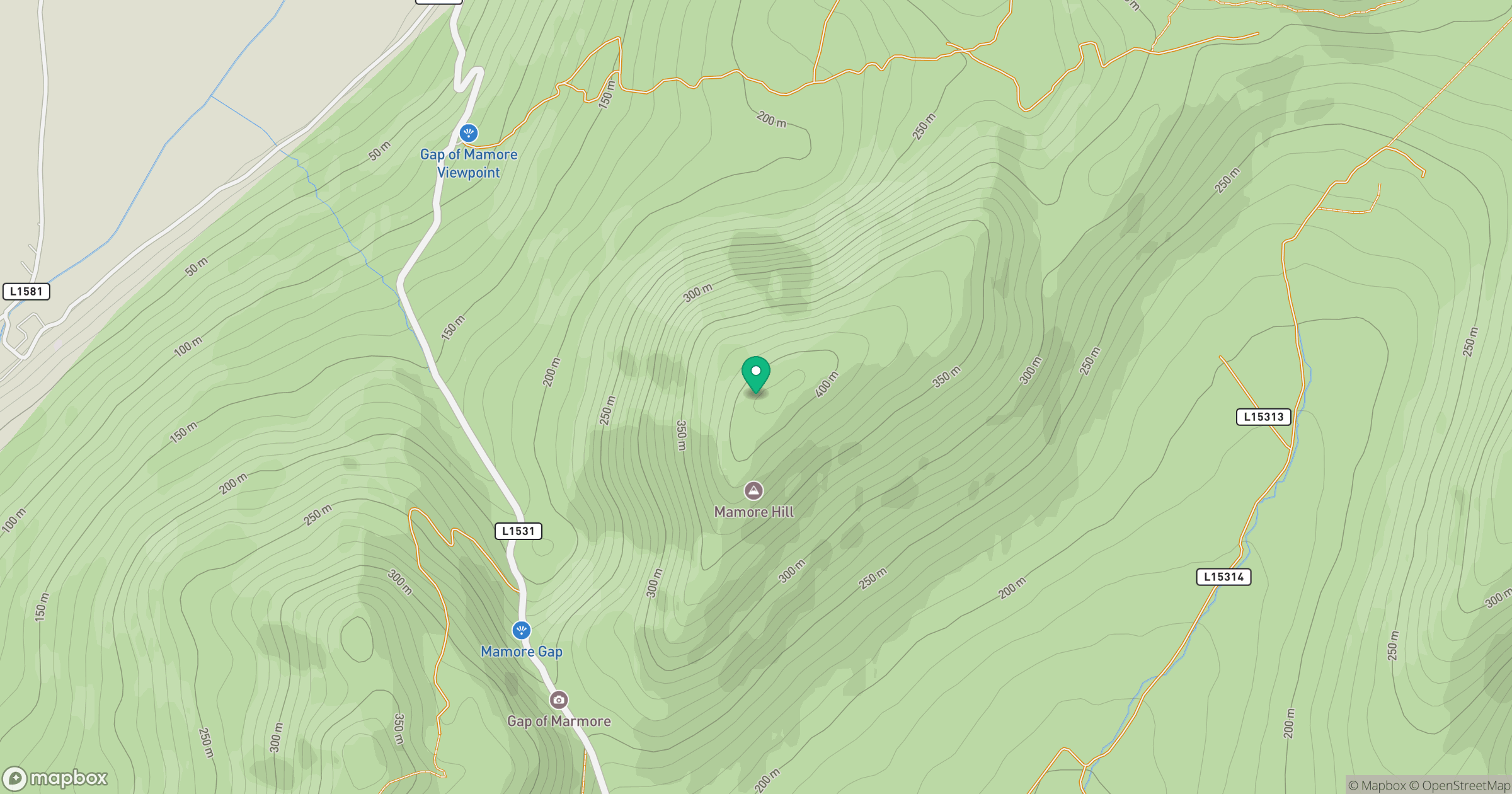
Grid reference: C324436
View on OpenStreetMapOpens a map in a new tab, centred on the hill.
Hills within 30 km
Straight-line distance, not a walking route or confirmation of access.
No comments yet. Be the first.